Sunday, July 29, 2012


July 22, Travelling with the boys and doing the Diamond Back

Awwwwh.  The first morning, Greg had picked a flower for me.  How sweet are my new traveling companions? 
Up and at 'em, and off we went, Greg, Doug and I, to finish riding the Blue Ridge Parkway, stopping to take photos, looking at beautiful scenery, commenting on the green grass coming right up to the edge of the road. It's a ribbon of pavement running through the woods.

One of the overlooks we (Doug, Greg and me) stopped at ... there was still some fog and haze out there.  The Blue Ridge Mountains are named for the blue haze that hangs over them naturally. 
The fog mostly cleared and we had a beautiful ride with some memories that will last forever.  It doesn't hurt to have them on the camera either since I can't even remember what I had for lunch yesterday.

This team of horses was ready to take people on the trail.  A wagon was hitched to them, and it would have been fun, but we were on iron horses and kept moving down the road after our brief stops.  I snapped this photo as we were walking over to the mansion.
We stopped at the Moses Cone Visitor Center, which was a mansion, and beautiful. We just stopped in, but they have tours if you want to do them. The building itself was a jewel set in the middle of the trees and I had to wonder how people got all the materials to a place like this and what they did, how far away from other things they were. It was so totally isolated.

Moses Cone Visitor Center.  Named for denim king Moses Cone who made his money in textiles, the 3,500-acre country estate sittinig at a 4,000-foot elevation, was his turn of the 20th century home.  It's spectacular.

This tree was by the center and was just so unique.
Greg had heard about a place called Little Switzerland and wanted to stop. It caters to bikers and some of the places to stay have garages to park the motorcycles. I saw an ice cream shop and that was all that mattered. But it was a nice place, and what I did not know at that point is that there's a ride (in North Carolina) called the Diamond Back (Route 226A), after a rattlesnake. It's about 190 curves in 12 miles. I figured why not? When we were done with that ride, we all agreed it wasn't as challenging as we'd thought it would be, but still a nice ride.

Little Switzerland.
We saw turkeys, which I thought was kind of cool, since I don't ordinarily see them on my travels. Greg is a good spotter, he sees the deer and the turkeys. I see some of it. But I don't spot so well.

The view from the top of Mt. Mitchell.  The visitor center is down below and our bikes are parked there.
There was another side trip off the Blue Ridge to Mitchell Mountain (Route 128), the highest mountain east of the Mississippi River. A grand total of 6,684 foot elevation. But it's certainly better than some of the elevations I've seen. Ha!!!

Yep, I'm standing right there.
We had walked up the quarter-mile trail to the observation deck, to look out over a spectacular view of the area … 360 degrees of it. The summit is encased in clouds 8 out of 10 days (kind of like our Mt. McKinley) so we were quite fortunate to see it all. The Rev. Elisha Mitchell, for whom the mountain is named, is buried there. I've seen that twice now, with the other time being in Trinidad, Colorado.

Rev. Mitchell's grave.
Yep, here we are, at the highest point east of the Mississippi.

There are so many beautiful overlooks on the Blue Ridge that it's hard to stop at all of them.

The Blue Ridge Mountains, running from North Carolina through Virginia, seem to go on forever.  It's 469 miles of hills, mountains, the Appalachians, the Shenandoah National Park and stunning views.  All is seen from riding the motorcycle from stop to stop.  Sometimes it seems like the next one is more gorgeous than the last.  But each has its own beauty.  It doesn't hurt that the road has twists and turns that will lure any motorcyclist. 

And there are lots of tunnels.  Tunnels and bridges are two things I really enjoy riding through and over.

Another spectacular view.   There really are so many roads and so little time.  The Blue Ridge starts in North Carolina, and you can get to it from Skyline Drive.  It ends near the Smokey Mountains and a Cherokee Indian reservation.

Stop!!!  Don't bother.  Photographer at work.  Greg taking the perfect photo of Doug at the high point on the Blue Ridge Parkway near sundown.

The highest point of the Blue Ridge Parkway.
After all our looking around and riding extra rides, we were at the high point of the Blue Ridge when sundown came. There was still about 30 miles of the parkway to complete, but we decided it would be better to get off of it and find a place to stay. Best Western works.

The sunset was incredible over the mountains.  There are so many photos, but I only can share one.
Pizza delivery also works when on the road, and that's what we did. I had the order placed before we'd even finished the registration for our rooms.

While we were eating pizza and sitting outside, I finally had to wonder about the rocket scientist. Yep, that's exactly what Doug was, for real. He'd worked for Lockheed-Martin, and I'm told if he shared what he worked on he'd have to kill us. Guess I don't need to know that bad. Don't suppose I can use that old rocket scientist line anymore; I'll have to be more respectful.

Greg is president of a company called Car-Mate Trailers. They make trailers for hauling behind cars and truck trailers, race car trailers and landscaping trailers. Their motto is “trailers that work for a living.”

One of our discussions revolved around Harley shirts. Doug talked about his, Greg talked about his. I did not talk about mine. Mine is an addiction, and I have to get a shirt from every dealership I visit. It's not a wardrobe anymore; it's a collection. But I would expect the Harley-Davidson company loves me as I have supported their business immensely through motorclothes purchases over the past 20+ years. And that doesn't even cover the motorcycles and accessories. That's a different addiction.

Thursday, July 26, 2012


July 21, my road will lead to the Blue Ridge Parkway

The day was not promising, overcast with drizzle. Not my favorite, but I finally got motivated, got packed up, got my raingear on and headed for the Blue Ridge Parkway.

I think the camo duck tape is much better than the yellow since it blends in better.
Fog. I couldn't see a thing. But I decided to go to the visitor center five miles in. The weather did not get any better, and I put on my flashers. By the time I reached the visitor center, I was wondering if I should have my head examined. Why was I on a road where I could run into something, or something could run into me, or a deer could cross my path and it would not be a good crossing.

Unbelievable fog.  I determined it was not in my best interest to continuue on in it.
At the center I talked with the ranger for a bit, and decided to turn around and go back and then head south on an Interstate for a bit. I'd try to get back on the parkway then.

While trying to get to the parkway I saw a sign for something called the Natural Bridge, so I stopped.

Before going to the bridge, there was a butterfly display. Yep, sounds a little lame. But I went in and it was something to behold. It's live butterflies in a rain forest type of setting, and they're flying free. There are also some that are in the various cocoon stages, and I saw one that was hatching, with its wings moving, but not yet fully ready to fly.

Some butterflies are well-suited to blend with the environment.  Butterflies taste with their feet, their top speed is about 12 mph, and they can see red, green and yellow.  Other interesting facts include a butterfly's wings are covered with thousands of tiny, overlapping scales, they cannot fly if their body temperature is less than 86 degrees and a group of butterflies is referred to as a "flutter."  All cool facts I did not know.
There's a set up where butterflies hatch from their coccoons.  This one was coming out, his wings were fluttering, but he wasn't quite finished with his transformation.
There were many beautiful butterflies.
They were not fearful of us at all; in fact, we were told to watch where we stepped because sometimes there's be some on the floor.  And there were.
And finally, check yourself before going through the second door to make sure none of the butterflies have escaped.  I did not aid and abet any butterflies in their flight for freedom.  It was a very cool exhibit and I was glad I'd gone and wandered through it.
From there I had to walk down 137 steps to get on the pathway to the bridge. I enjoy rock formations, and this one promised to be a good one. It was, although I had to walk a ways, still in my boots and rainpants. That was a mistake. I should have lost the pants and changed into my sneakers. Oh well. Too late. By the time I got to the bridge, I also wanted to walk up to the Monacan Indian display, then on to Lace Falls, about a mile and a half back. So, had to do it. Wanted to see the falls. I was sweating like a pig. The rainpants act like a sauna, so I must be losing weight with all the sweat that was pouring off of me.


There were some beautiful old tree formations.  Even if they're dead, they're still beautiful.
A stream runs through the area, adding to the uniqueness of the natural bridge.
The natural bridge is solid grey limestone.  It's 215 feet high (55 feet higher than Niagara Falls), 40 feet thick, 100 feet wide and spans 90 feet between the walls.  It contains 450,000 cubic feet of rock.
The Natural Bridge area is framed by the Blue Ridge Mountains. It was owned by Thomas Jefferson, traversed by Civil War soldiers and surveyed by a young George Washington. In fact, there are initials carved in the rock by Washington. You can't see them anymore, but they're there (or so I'm told).

The perimeter of a Monacan Village is called a palisade.  It is to protect the inhabitants from wild animals and others who might try to wrest their villages or land from them.  The village is circa 1700.  The Monacans were a Siouan-speaking people who migrated to this region from the northwest.
The round house, called an ati or wigwam, was a single-family dwelling.  It's covered with bark and mats, and like this one, could be thatched with cattails.
Lace Falls,on Cedar Creek, originates 180 miles away, at the Alleghany River.
I met Galen and his wife, Joyce, at the bridge.  Galen and I walked and chatted on the way up.  They were very nice people who hope to visit Alaska, and I enjoyed meeting and talking with them.  He had a lot of information about the area that he was willing to share with me.
After having a lunch of a pretzel and cheese, topped off by Hershey's ice cream, I got back on the road to try to run the parkway again. I stopped to gas up and saw several bikers taking off rain gear. I asked one of them, a guy, about the weather. He wouldn't even acknowledge me. WTF????? Good thing I was being ladylike or I might have asked him if he had a problem with female bikers. Rather, another lady must have seen my look of disgust because she answered the question. They'd had some pretty heavy rain and fog for about 15 miles.

I made it onto the Parkway again.  This time to run a lot of miles, and enjoy it immensely.
I was going for it. I finally made it onto the parkway for more than 5 miles. The Blue Ridge Parkway is set up high, with drop offs on both sides, leading down mountains covered with trees. The foliage is incredible, so dense you cannot see through it in many places. I stopped to take photos that cannot do any justice to what I saw.

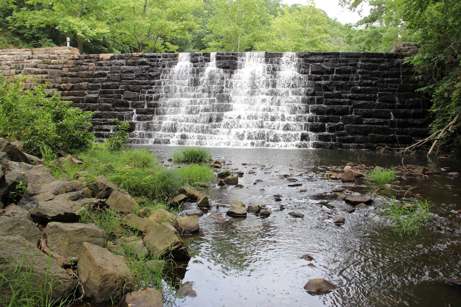
This was a dam with a reservoir on the other side.  Beautiful gems like this one are up and down the Blue Ridge Parkway and if you don't stop you could miss one.
The sides of the road are green right up to the pavement. They must cut it because it looks like someone's lawn. The trees are like canopies covering the road in many places, the air is fresh and clean, and there are flowers growing along the road here and there. The curves are gentler than some of the ones on Skyline Drive.

I walked a few of the trails and there was still fog but it was quite cool although a little eerie.
I really like this road. I've seen the photos, but they do not do justice to what it is in real life. However, there are a lot of trees and branches down alongside the road. I'm wondering if there was a storm because a lot of trees look like they've split. Strong winds or something. Mother Nature at her finest.

I saw two groundhogs, and two deer … a doe and a small buck. There's always something to see. Funny. I'd met a guy at the Harley shop yesterday and he told me he'd ridden a couple hundred miles of this road and it was trees, and more trees. He wondered how many trees he needed to see. In other words, he was bored. I can't imagine that. There is always something different around the next bend, an animal, a funny-looking tree, an overlook. The twists and curves are a wonder for those of us who love the open road but not the straight road. He must be a city guy, preferring to run tavern-to-tavern. That's not my style. Ride, baby, ride!!!

At a crossroads there were a couple of guys stopped, so I stopped to see if they were okay. They were trying to figure out where the next gas stop was and didn't have a map. They were using a GPS. I had a map so they got it all figured out. They said I could ride with them, I said “really?” and so off we went. Greg and Doug, from Pennsylvania and Colorado, nice guys both.

Greg and Doug striking their tough guy poses at the motel in Fancy Gap.  The motel was not fancy.
We stopped at a small motel in Fancy Gap, Virginia, just off the parkway at Mile 200. We joined up for dinner, and then here I am. No phone service, but I have Internet. Go figure.

July 20, no miles, but covering multiple states at a single bound

I got on the road about 8:30 a.m., heading to Winchester, Virginia. I had two Harley shop routes written down, and hoped to get a 10,000-mile check up. I called and told them I was about 90 miles out, and asked if I could get the service done today? Yep, come on down.

As I rode, I started to follow the wrong route. One was written on one side of the note paper, and the other on the reverse side. And you wonder why my friends call me directionally-challenged??? Ha!!!
I stopped to take a look, made a correction, it was only minor, and headed on to Winchester. Then my thought was that maybe I was heading to the wrong Harley shop. Perhaps I'd called the one in Williamsport. So rather than stop and check the phone number I'd used, I just bulled on ahead. Voila!!! It was the right one, and in I went.

What's nice about many shops is that they have an Internet connection, so I'm sitting here right now working on my blog. However, my camera is on the bike, along with the memory card with yesterday's photos. Maybe I'll go get it. Done. But I didn't get finished … they completed the service, and I was on the road again. It had rained pretty heavily, so I was geared up, including using duck tape to tape my pants to my boots so road water wouldn't get up inside and get my pants wet. However, it was a mere sprinkle at this point.

I headed to Front Royal, Virginia, where Skyline Drive begins and runs through Shenandoah National Park. I knew it was about 100 miles long, so I figured 3-4 hours … putting me in Waynesboro about 6:30 or 7 most likely. And, I have a senior pass so I get in free for the rest of my life. You can get them when you turn 62. Well worth the few dollars it costs if you're going to go to any of the national parks.

There was beauty everywhere I looked, and greenery that didn't look real..

The road is surrounded by nothing but beauty.

It seems like there are flowers everywhere.
The ride was awesome. I soon peeled the tape loose and took off my rainpants, but kept on the jacket for warmth. The road was pretty deserted, so I'd ride for miles without ever seeing another car. If one came up behind me, I'd wait for a straight stretch and motion them on so I could once again have the road to myself.

Mary's Rock Tunnel.  The fog was rolling in as I was parked reading about the tunnel.  Workers drilled, blasted and cleared for three months through 600 feet of solid granite to complete the tunnel, considered the greatest construction challenge of Skyline Drive.  Twice each day workers drilled 40 holes, each 12 feet deep, filled them with a total of 500 pounds of dynamite and detonated them.  Three 8-hour shifts of 15 men worked daily to blast and clear by rolling the rocks and debris over the edge.   In January 1932 the men saw daylight at the other end.  Almost immediately adventurous sightseers drove through.
At one point I passed a sign that said 3,680 foot elevation … the high point in the park. Wow. I come from the land of the Great One – McKinley. I know elevation and 3,680 ain't!! But the Shenandoah is beautiful and I was happy to be riding in its splendor.

I stopped here and there, but there was heavy fog and really nothing much could be seen from the pullouts. But that didn't matter. The air was cool, fresh and clean-smelling. I relished the beautiful road which appeared to be newly paved and painted, and the greenery and rolling hills. I was no longer running the slabs, breathing in the exhaust fumes of hundreds of cars and trucks traveling the same Interstate I was. Well, maybe I missed the smells of delicious food just a little.

Even with fog, it's beautiful country.
At one point a white car came racing up behind me, so I let it by. It pulled into the very next overlook and I was wondering when I saw the driver get out with his son and take him into the weeds. Then I understood why he was in such a hurry. Except when I went to pull out, he was also leaving so I let him go first. He took off down the road like he was on a Grand Prix course. If you want to drive 20 mph or better over the speed limit in a park, why are you in the park? Why not just take the Interstate? It's not as though you're going to see anything racing through as fast as you can.

Imagine, flowers growing right up to the roadway. 
There are a lot of mountains around here with some history to them.
Like Brown's Gap, a piece of impressive history.
Brown's Gap.
In fact, I saw two deer. One I got no photos of because it took off. The other I got a couple of crappy photos. I was trying to balance my bike without putting down the kickstand and take a photo around the windshield.

The best deer photo isn't great.  But I love deer so posting it anyway.
I thought of my trip on this same road in 1993, with Hobbs. I so enjoyed it today, and wonder if back then, being a pretty new rider, if the curves intimidated and scared me. Probably. But a lot of miles and experience can take some of the fear away, while leaving behind an awe of the road along with a healthy caution of what may lie ahead … curves, cars on the wrong side of the road, animals. But nothing even came close to a hazard of any kind. Yes, it was a great riding day.

Of course I had to have a photo of this sign.
Richard from New York's lady, Kim, had a birthday.  She doesn't eat cake so I told her I'd take care of it.  Actually, spotted this little pecan pie and I used to like them, so that's what I had to celebrate her birthday.  Happy birthday, Kim.  Hope it was absolutely the best one ever.
Waynesboro, Virginia was my final resting place for the day, with a Cracker Barrel calling my name. Once again, even Skyline Drive leads to food, spicy grilled catfish.

Tuesday, July 24, 2012


July 19, 2012 … I love chocolate


Need I say more?
I was in the neighborhood, so of course I would want to go to Hershey, Pennsylvania, and check out the home of Hershey chocolate.

Yep, that's exactly it.  In fact, as I drove into town I could have sworn I smelled chocolate.,


Wrapped like it's in tin foil (lightpost).


Unwrapped, and brown like chocolate (lightpost).
The factory is visible, but it's not a tour. What you can do is go to the Hershey Chocolate museum. Which I did. The museum tour tells the story of Milton Hershey.

And through the doors I went, heading for a chocolate overdose.
He built the business which is very impressive, and even bought out Reese's (those wonderful peanut butter cups), invented a use for chocolate powder, (think hot chocolate), and revolutionized the art of making and selling chocolate candy … read kisses, including inventing a machine to wrap each kiss individually so the average and ordinary person could afford to purchase a piece of chocolate candy. I love that guy. Best of all, there are now all kinds of kisses, white chocolate, almond, white and brown chocolate, just chocolate. How do I love you (my little kiss), let me count the ways … or better yet, kinds and individual tastes.

Basically a bathtub, these were used to transport the chocolate to the next step in the process.
The kiss-wrapping machine revolutionized the sale of candy.  Now the ordinary person could purchase a little kiss of heaven.  Prior to this, candy was mostly sold in bulk so only the rich could afford the luxury.
Even more importantly, he cared for his employees, built them a community where they could take time off, play in parks, and own their own homes with low-interest loans, unlike in some other industrial towns. He donated money to a school for children, and I know personally one person who grew up there. And he grew up to be a nice and great person.

Wish I had this sign.  It's proof we should eat chocolate every day.
Heading to the lab.
The other thing I did was sign up to make a bar of chocolate. The bar I was signed up to make was a “beach bar.” This bar would have a “tattoo” of starfish, shells and fish on it, and would use graham cracker crumbs and sea salt for sand.

Do I look like a chocolate chef?
We all had to clean our hands and don a hair net and apron. Then we poured our liquid chocolate into little molds, decorated them and handed them back to be put in the refrigerator to harden.

Making my little bar of chocolate.
We even got to lick the spoons when we were done.  Don't waste any of that chocolate.
Meanwhile we got a lesson on where chocolate beans come from and how it ends up being something worth eating. The whole cacao bean, rain forest, harvesting process is quite interesting, and I have a whole new appreciation for chocolate and what Mr. Hershey did for those of us who love chocolate. I also am told the cacao bean is considered a fruit … so how many servings of fruit are we supposed to eat in a day? I'm into that kind of progressive thinking.

Beans, milk and sugar.  Pretty simple if you have the right combination.  One of these pods usually has about 75 pods, containing 30-40 beans, enough to make one standard-sized Hershey bar.  The trees can be harvested twice a year.
The moist beans are laid between leaves and allowed to ferment for a few days.  Hershey purchased beans from various bean farms throughout the world where they're grown, although all the beans originally come from one area, prior to being exported and planted in other rain forests.
One of the cacao pods.
The beans inside the pod.

A conching machine is used to grind up the beans.  It takes four days and nights to grind the beans smooth enough to use in chocolate.


It's almost this simple.

My chocolate bar.  I ate it all, too.  It would have melted on the bike.

From Hershey I continued down the road to something else I'd seen, Indian Echo Caverns. I like caverns, so I'd decided to stop and check this one out. While it's not Carlsbad, it was a fun tour, and I got some photos to share. The walk in and out involves 71 steps … many of varying sizes, so you had to be careful when stepping. I did not see any bats, although there are bats in the cave. Darn. I was kind of looking forward to seeing some.

I was also surprised to be able to take photos with flash … so I photographed away.

There were some beautiful formations, but hard to get good shots.
But I did get one or two.
So like caverns.
Dripping water has started a little stalagmite.  It looks like cooked egg white to me.
Had lunch and then headed to Battle Creek Harley Davidson, near Gettysburg. I figured I needed a shirt from there. By then it was late enough to stop for the evening, after 6 p.m., plus the weather was looking iffy and I didn't have a plan downloaded for my next stop.

Cute little piggy.

I love the painted animals I've seen.

Because it's Battlefield Harley-Davidson.
A Perkins restaurant did right by me … my favorite salad there is a BLT chicken salad with honey mustard dressing. It's been a long time and my mouth was watering since I'd first seen a Perkins sign. That particular problem and the accompanying drool has been taken care of now.